Huang, Qinghua
Main interests include seismo-electromagnetics, magnetotellurics, and computational geo-electromagnetism. Developed the numerical technique of simulating co-seismic electromagnetic signals associated with the rupture of a finite fault model, which can be applied to the interpretation of seismic electromagnetic data. Proposed the mantle source model for Datong volcanoes based on 3D inversion of magnetotelluric data. Developed a parallel 3D staggered grid pseudo-spectral time domain (PSTD) method for ground-penetrating radar (GPR) wave simulation and a curved grid-based 3D transient electromagnetic (TEM) modeling with topography, which can be applied to 3D electromagnetic problems with complicated models.
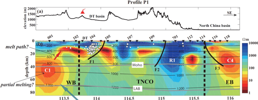
The resistivity model from 3D inversion of magnetotelluric data in Datong volcanic area. (a) Elevation along profile P1. (b) Vertical slice of resistivity model along profile P1 (Zhang, Huang et al., EPSL, 2016).
Berndt, Thomas A.
Rocks contain a multitude of magnetic minerals that can record and preserve the magnetic field of the Earth. These records can give insight into the geomagnetic field behavior itself, but also about geodynamic (e.g. tectonic), environmental, and surface processes. A particularly intriguing application is the use of such magnetic minerals to track and date surface processes due to catastrophic events such as tsunamis, landslides and glacial floods. Recent successes have shown that this method applied to boulder deposits can give insight into natural hazard risk patterns.
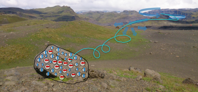
Photo of a meter-sized boulder that was emplaced by a glacial flood in Iceland, with superimposed illustration of microscopic magnetic inclusions that contain a record of the boulder’s motion (Berndt & Muxworthy, 2017, Geology).