Wang, Teng
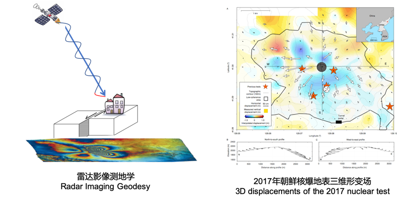
Radar imaging geodesy uses electromagnetic waves emitted by Synthetic Aperture Radar (SAR) to measure surface displacements, such as caused by nuclear explosions (Wang et al., Science , 2018).
Ground deformation measurements are important for understanding the physical mechanisms of many geo-processes such as tectonics, earthquakes, volcanic eruptions, landslides, glaciers, nuclear tests, mining actives, ground water migration and many more. Satellite geodesy is a science of observing and understanding Earth’s time-varying shape, gravity field, and rotation through satellites; microwave remote sensing is a technology based on space- or air-borne radar to study the surface scattering characteristics. The combination and intersection of the two forms a new research field in geodesy: radar imaging geodesy, i.e., measure, interpret and understand changes in geometric and physical properties of the Earth's surface based on radar images.
Radar image geodesy uses Synthetic Aperture Radar (SAR) as the primary data source. SAR is an active microwave remote-sensing sensor that emits electromagnetic waves and records the signals reflected back from the earth, forming radar images. Microwave signals are transmitted and received independent of sunlight and can penetrate clouds, so SAR imaging is not affected by illumination or meteorological conditions. The amplitude and phase information in SAR images can be processed to accurately measure the deformation of the earth's surface from a few millimeters to tens of meters, playing an indispensable role in basic research and application fields such as geophysics, environment monitoring and nature hazard mitigation. The research involves digital signal processing, elasticity and fluid mechanics, physical model inversion, and big data and artificial intelligence.
At present, SAR satellites have already achieved global short-repeating observations, and many space agencies around the world, including ours, have followed up with SAR missions. In addition, a number of private space companies have begun deploying small SAR constellations, with multiple satellites in orbit. Adequate data resources allow us to measure surface deformation in multiple spatial and temporal dimensions and to invert for various geophysical parameters from the Earth's crust to the mantle, and to understand the physical mechanisms of these geological phenomena. At the same time, geological hazards such as landslides, mudslides, and ground collapses often cause significant casualties and property damage on a global scale. The use of time-series SAR images to monitor local deformation anomalies over a wide area will also play a very important role in the prevention and mitigation of hazards and the rational use of resources. It is believed that in the near future, radar imaging geodesy will improve further the spatial and temporal evolution of surface deformation and reveal the physical mechanism of various geo-processes in greater depth.